Municipal geoinformation system (MGIS)
Municipal geoinformation system (MGIS) is a tool for solving problems of city management
Municipal geographic information system is a tool for the integrated management of territory, which provides information support to various areas of municipal management, including:
- urban planning;
- land policy;
- the management of municipal property;
- the organization of the transport scheme;
- improvement;
- other.
The system is designed in accordance with the Federal legislation in the field of development of Information systems for urban planning (ISEPA).
Municipal geoinformation system contains a whole list of cartographic information in digital form, made in the same coordinate system, the General system of classification of the terrain objects in the General mapping rules:
- planning documentation (General plan, zoning scheme of projects of territory planning, projects, land surveying);
- targeted plan of the city;
- standby plan;
- the schema of an existing land use;
- the scheme of location of objects of cultural heritage;
- other cartographic and thematic materials.
In addition to cartographic materials, the system contains a powerful structured databases and full-featured information system, in collaboration with the digital vector map.
The development of the system is carried out using a geographic information system "Ingeo" tool and environment "Inmeta the" development of CSR "Integro", city Ufa.

The main objectives of the system
- The creation of a perfect structural-functional organization of the city.
- Improving the efficiency of the management of the complex resources of the territory.
- The increase in revenues in budgets of all levels. Changes in the structure of revenues of local budgets by increasing (30%) of the shares relating to payments for real estate.
- Increasing the investment attractiveness of the territory due to:
- Rational development of the territory taking into account the public interest by better structuring of the territory and reasonable regulation of its development;
- Guaranteeing property rights on real estate;
- Appropriate long-term administrative and financial policies;
- Automation of benefits payments for the property for the period of design and construction of specific items of property;
- Simplification and acceleration of procedure of registration of transactions with real estate.
Main missions of the system
- The formation of a single information space between the services and departments of the city for the storage and exchange of information on the site. Common information space contains data about the territory (land, facilities, property rights, etc.) associated with a cartographical basis.
- Creating a single repository of planning documentation containing restrictions on the use of land. The list of documents determined by the city planning Code of the Russian Federation from 2005.
- Central registry of information on spatial objects, property rights to them, the cost, terms, technical data and so on.
- Information support architectural planning activities.
- Objective accounting of municipal property, information support of each object during its life cycle.
- The enterprise-wide electronic duty of the city plan.
- Accounting and certification of engineering network facilities, schedules of preventive maintenance.
- Formalization and automation of internal processes in the organizations related to territorial management.
- Implementation of a system of intradepartmental and interdepartmental workflow.
- Facilitation services for individuals and legal entities through the creation of a system of "one window" on the basis of a single data repository.
- The integration of all city services and departments on the basis of address plan.
Maintenance of information resources of the municipal geographic information system
- Monitoring site, statistical analysis, evaluation of the existing condition of the territory and forecast the urban development of the municipality.
- Analysis of activity of subjects of property relations and urban planning.
- Maintain zoning regulations of the town (district).
- Maintenance duty city maps (scale 1:500), targeted plan.
- Accounting of subjects of town-planning activity (legal entities and individuals).
- The account of the population.
- Consideration of territorial areas in the city (functional, sanitary protection, water protection, maintenance, and more. etc.).
- The accounting of real estate objects (premises, land etc.).
- Registration of rights to real estate objects.
- Account planning documentation.
- Accounting for the design and construction of real estate, providing a unified technological process of obtaining permits for design and construction of real estate.
- The formation of the cadastral documents (urban planning passport of real estate object cadastral certificates).
- Reporting to parent organizations.
- Maintaining an archive of information of the municipal system upon expiration of the term of relevance, the history of urban changes search information stored in files.
- Model Agency electronic documentation (function-level urban property organization).
- Analysis of the activities and property of the organization.
Information resources of municipal geographic information system
The integrating element for all the diagram in the organizations is the duty of a digital topographic plan of the settlement, which shows the spatial location and corresponding characteristics of major real estate.
A number of organizations have the right to map your information (for example, bodies of architecture and urban planning), the other mostly just read the information (for example, organs property management, BTI), but in any case, a digital map is one of the most important information resources.
The instrumentation system
1. GIS "Ingeo"
GIS "Ingeo" is a set of software products, allows you to create vector topographic maps, with the correct topological structure (results of land inventory, topographic plans of settlements, master plans of enterprises, schemes of engineering networks and communications, and the like).
2. AIS "Monitoring"
Automated information system "Monitoring" is designed to automate the task of ensuring town-planning activity in the organs of architecture and town planning at the level of the municipality. This system allows you to organize the accounting and registration information about planning documentation ISEPA, records of ISEPA in accordance with the provisions of the town planning code of the Russian Federation and decrees of the government of the Russian Federation No. 363 dated 9.06.2006 "About information support of city planning activity".
3. AIS "Auction"
Automated information system "the Auction" is intended to capture information and documents in preparing bids for the sale of rights to conclude contracts for the development of built-up areas and lease contracts of land plots designated for construction.
4. AIS "Property"
Automated information system "the Property" is designed to automate the activities of large enterprises, regional and municipal organizations engaged in the management of various real estate: land and located on them objects anchored to them, as well as movable property (vehicles, equipment, other movable property).
5. AIS EPA 363
Automated information system of ensuring town-planning activity 363 developed on the basis of the decree of the Government of the Russian Federation №363 "About information support of city planning activity" and the order of the Ministry of regional development of the Russian Federation No. 85. The system of ensuring town-planning activity designed to provide the accounting, registration, storage and provision of urban planning documentation.
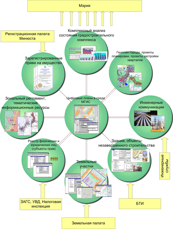
The development of municipal GIS is the integration of different vertical (between levels of government) and horizontal (among units of one level) of information resources to provide access to senior management of the appropriate level to the complex heterogeneous information about the site.
The development of the idea of horizontal integration has led to the creation of so-called distributed geographic information systems (DGIS).
A distributed system is a tool of collective management of digital maps of different departments of the municipal administration, which enables development of in-house systems based on General cartographic materials.
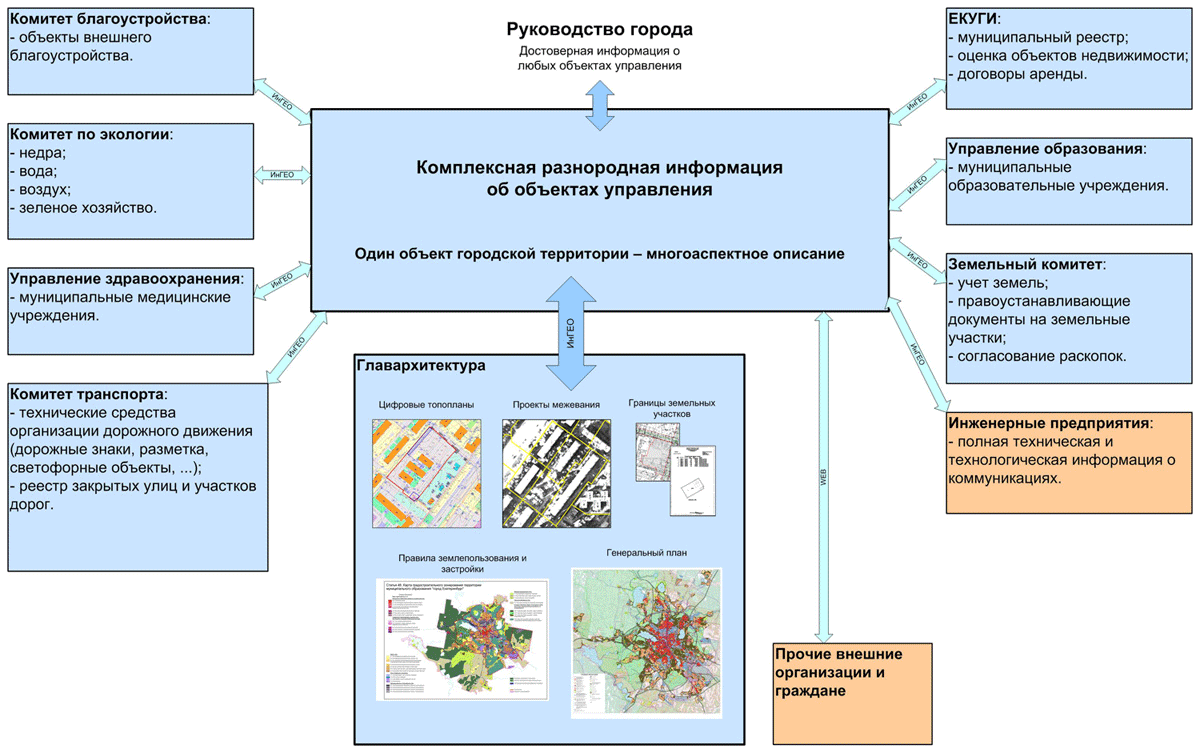
A distributed geographic information system
A distributed geographic information system integrates information from all city services on the basis of the digital topographic map. For city leaders this system is a tool that allows you to see the complex heterogeneous information about the object.
The municipality "Yekaterinburg"
MGIS Ekaterinburg for the Department of architecture and MU "the Center of preparation of permissive documentation for construction" developed in 2004.
Subsystem MGIS Ekaterinburg are used for:
- formation of land plots for auction,
- the preparation and tendering,
- of surveying the land,
- records management in the system of "one window",
- collection of technical conditions
- accounting engineering research,
- management of town-planning rules of land use and development,
- registration and issuance of information from the information system of ensuring town-planning activity,
- preparation of layouts of the land plots on the cadastral plan of the territory and town-planning plans of land plots.
Digital vector maps MGIS Ekaterinburg include city plans of scales 1:500, 1:2000, drawings of the General plan and Rules of land use and development.
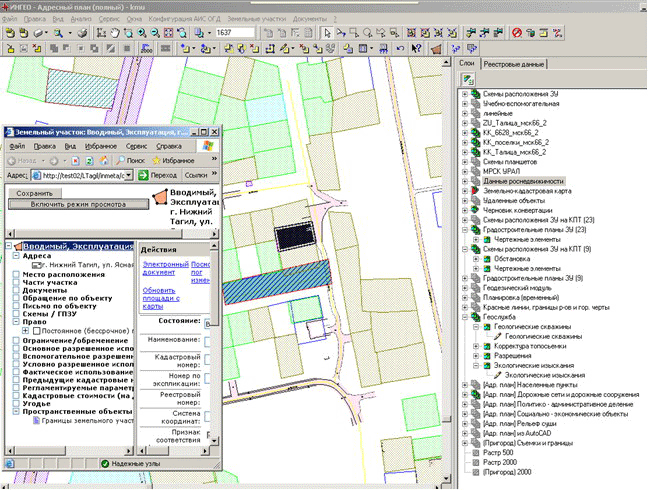
Nizhny Tagil
MGIS Nizhny Tagil for the Management of investments, architecture and urban development. "geographic information system" is being developed since 2008.
Subsystem MGIS Nizhny Tagil are used for:
- accounting engineering research,
- archival prepared land allocation cases
- town planning preparation of land,
- conducting the address register,
- documentation,
- registration and issuance of information from the information system of ensuring town-planning activity,
- preparation of layouts of the land plots on the cadastral plan of the territory and town-planning plans of land plots.
Digital vector maps MGIS Nizhny Tagil address include city map and land cadastral map 1:2000, city plan scale 1:10000 raster plan M 1:2000 for rural settlements, drawings of the General plan of the city.