GIS risk management of emergency situations of natural and technogenic character
GIS risk management of emergency situations of natural and technogenic character are one of the most effective tools for the analysis of the relief, geological, industrial and socio-infrastructural characteristics of a particular area to plan protect the population from large-scale disasters.
A similar analysis is carried out monitoring of the territorial centers based on the geographical information system (GIS), the relevance of which directly depends on the effectiveness, efficiency and quality of decisions in emergency situations and elimination of their consequences.
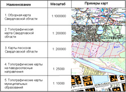
Ural regional information and analytical center of JSC "Uralgeoinform" provides in Eekaterinburg a wide range of mapping services including the development and upgrade of the geographic information database based on the best-selling software and digital equipment.
Prepared geographical information system includes the following sections:
- Register spatial queries;
- Prediction natural and technogenic emergencies;
- Ranking of territories;
- The output documentation.
Territorial GIS management of risks of emergency situations of natural and technogenic character
One of the tasks of state authorities (SA) – ensuring safe conditions of life and activities of the population and territories. In order to ensure control over the condition of natural and man-made sources of emergencies, early forecasting of possible emergencies and their management, the government of the Sverdlovsk region was established in the Territorial monitoring system, the management body which is the Territorial monitoring center of the Sverdlovsk region. (TMC). The main objective TMC - informational support of managerial decisions on the prevention and liquidation of emergency situations on the territory of Sverdlovsk region.
In order to automate the activities of the TMC according to the order of EMERCOM of the Sverdlovsk region (EMERCOM of Russia in Sverdlovsk region), Ural regional information and analytical centre ", Uralgeoinform" since 2003, developed a GIS risk management of emergency situations.
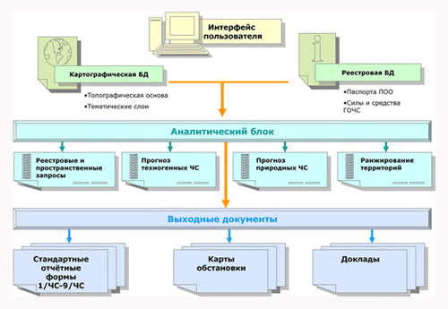
Components of GIS:
 |
Digital maps are the basis for performing spatial analysis, modeling emergency situations, applying thematic layers. Thematic layers are based on tabular, text, graphics, information, databases, and simulation results to analyze the situation and forecast the risks of emergencies. To display thematic layers developed by the classifier. |
The register of potentially dangerous objects
The register of potentially dangerous objects is a relational database that includes information on organizations with potentially hazardous objects and the description of such objects in accordance with the developed classifier.
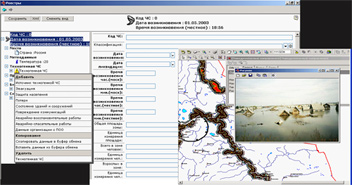
In the Registry system requests through the address data of the organization, by type of potentially hazardous objects, and other parameters. The user can obtain complete information on the selected object rendered on a mapping base. Selecting the object in the Registry, you can see its location on the map and Vice versa by selecting an object on the map, go to the Register of potentially dangerous objects and automatically receive all the necessary information.
Block "Emergency"
This unit is designed to collect information on the facts of the emergency in accordance with the approved EMERCOM of Russia forms 1-4/7-9 CHS/CHS and storage of simulation results of emergency
The unit "Forces and means of formations of civil defense"
The unit is designed to store information about the units of permanent readiness for liquidation of consequences of emergency situations, forces and means of observation and laboratory control (OLC). Also, this block contains the information about the characteristics of the groups (type of building purpose, location, time on-duty units, the list of types of assistance provided, list of available equipment and technology, the range, number, affiliation);
The block of reference data
This block contains the STANDARDS, Government regulations, departmental documentation of emergency.
Simulation of emergencies and prediction of their consequences is carried out based on techniques developed by RSRI EMERCOM, Gosgortekhnadzor, automated "Uralgeoinform". Developed programs allow:
- assessment of the consequences of accidents fire and explosion hazard facilities;
- the assessment of the impact of forest fires;
- assessment of the effects of hurricanes;
- the calculation of the emissions of harmful substances during combustion of oil and oil products;
- forecasting the extent of contamination in case of accidents on chemically hazardous objects and transport;
- assessment of the consequences of accidents in fuel-air mixtures;
- assessment of the consequences of chemical accidents;
- three-dimensional terrain modeling for the prediction of flood during the floods and floods;
- determining the optimal route of experts on transport networks and facilities in the emergency area.
- Modeling of consequences of technogenic and natural emergencies;
- Prediction of flood during the floods, the catastrophic flooding and destruction of hydraulic structures
- The definition of optimal routes;


