Photogrammetric processing of images
Photogrammetric processing of images
For processing enterprise "Uralgeoinform" is equipped with digital photogrammetric stations, high-precision photogrammetric scanners and other specialized equipment, technical and software: Photomod, Geomatica, Geomosaic, ERDAS, and ENVI. Experts workshop of digital photogrammetry provide a full range of photogrammetric processing of results of space imagery and aerial photography:
- Laboratory work in digital stereo-photography:
- preparatory work
- photogrammetric densification of horizontal and vertical survey ground by constructing a route or block of photogrammetric networks
- stereoscopic photography
- creation of digital terrain models and digital elevation models
- Orthorectification and creation of orthophotomaps of scale 1: 500 – 1: 200 000 on materials of space imagery and aerial photography
- The interpretation of orthophotos and the creation of original digital topographic maps and plans
 |
 |
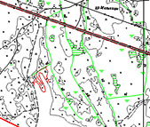 |
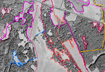
| Creation of digital topographic map on orthophoto Prigorodny district of Sverdlovsk region, scale 1:10 000 | ||
Creation of digital topographic map on orthophoto
The list of completed photogrammetric processing of results of space imagery and aerial photography on the territory of the Ural Federal district in 2005 to 2009.
- Created orthophoto scale 1: 10 000 for the territory of the Kamyshlovsky, Sukhoi log, Beloyarskiy, Bogdanovich, Sysert districts of Sverdlovsk region (4014 sq. km) satellite images (Spot, 2.5 m, 2006)
- Created orthophoto scale 1: 10 000 for the territory Irbitsky district of Sverdlovsk region (3167 sq km) based on aerial survey data 2000.
- Generated digital topographic plans of the cities of the Sverdlovsk region by the method of stereo-photography: Nizhnyaya Tura, scale 1:2 000 (YSL 2005), Kachkanar, scale 1:2 000, Asbest scale 1:1 000, 1:2 000 (YSL 2003), MapInfo
- Созданы цифровые топографические планы населенных пунктов Свердловской области:
- Sosva, scale 1:2 000, the local coordinate system (LCS-66), 11 sq km in Ingeo format. Updated on aerial survey data, 2007
- Talitsa and Trinity scale 1:2 000, the local coordinate system, 44 square km in Ingeo format, MapInfo. Updated in satellite imagery 2005
- Pyshma scale 1:2 000, the local coordinate system 26 sq km in Ingeo format.
- Created orthophotomaps and planning and cartographic material scale 1: 2 000 in 46 settlements of the municipal formations of the Sverdlovsk region, Pervouralsk City district, Alapaevskiy municipal unit, urban region, Nizhneturinskaya city district, North Ural city district, Pyshminsky urban district the urban district, the total area of 263 sq km in MapInfo format.
- Created orthophoto scale 1: 25 000 on the territory of the Tyumen region (54500 sq. km) satellite imagery (Spot KA, 2.5 m, 2005)
- The generated orthophotos (285 nomenclature sheets), scale 1: 25 000 on the territory of oil and gas fields in KHMAO – Yugry according to the materials of space shooting (QuickBird 0.61 m, 2006 and KA Spot, 2.5 m, 2006)
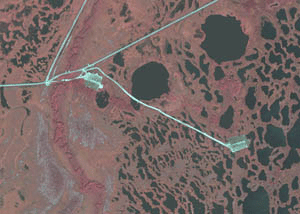 |
A fragment of orthophotomap of scale 1:5 000 created by satellite image of 2006 QuickBird (0.6 m resolution) for the territory of the oil field |
- Created digital topographic maps of scale 1: 5 000 (250 nomenclature sheets) into the fields of TPP Langepasneftegaz, TPP "Pokachevneftegaz" KHMAO – Yugry according to the materials of aerial photography (2005-2006) MapInfo;
- Created orthophoto scale 1: 10 000 for the territory of sites of gas pipelines "Gazprom transgaz Surgut" (200 sq km);
- Created orthophotoplans on the territory of the Republic of Bashkortostan, scale 1: 25 000 (18638,6 sq km) - based on satellite imagery (Spot, 2.5 m) scale 1: 2 000 (2332 sq km) and 1: 10 000 (89208 sq km) - based on aerial survey data, 2007.;
- Created and updated according to the materials of aerial photography, digital topographic plan of scale;
- 1: 5 000 (YSL 2007). the territory S. of Buzdyak of Republic of Bashkortostan (8,84 sq. km);
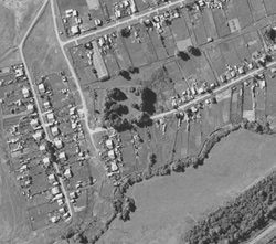 |
A fragment of orthophotomap scale 1:10 000 |
- The generated orthophotos (418 nomenclature sheets) scale 1: 2 000 for the territory of Togliatti in Samara region based on aerial survey data, 2005;
- Created digital cartographic base scale 1: 5 000 format Ingeo for the purposes of urban development on the territory of S. Raevskiy, Blagoveshchensk, p. eng. Yurmash, S. Zhukov, S. Zubovo (Ufa district), a number of populated points of the Birsk district of Bashkortostan Republic (YSL, 2007), the city of Ivdel of Sverdlovsk area (YSL 2006);
- In the framework of the program "Creation of automated system of state land cadastre and state registration of real estate" aerial photography of the territory of the Republic of Bashkortostan created a digital photographic maps with the subsequent drawing of cadastral information, including cadastral division.
Photo scale 1: 2 800 000 settlements consisting of 3 to create, including↑", Aurgazinskijj, baymaksky, Belebeevsky, Belokatayskaya, Beloretskiy, Birsk", blagovarsky, - Buzdyak, burzyansky, gafuriyskiy, duvanskiy, diurtiulinsk, Zianchurinsky, Zilairsky, Glinskaya, ilishevskiy, ishimbayskiy, at the Karaidel, Kiginskoe, Kushnarenkovskogo, Meleuzovsky, Meletiskii, Mishkinskogo, Narimanov, Salavat, sterlibashevskogo, Uchalinsk, " Fedorovsk, haybullinsky
Photo scale 1: 10 000 on create in the part 51 / the Council of the municipal district, including Aurgazinskijj, Belebey, Birsk", blagovarsky, - Buzdyak, duvanskiy, diurtiulinsk, Zilairsky, Glinskaya, ilishevskiy, ishimbayskiy, Kiginskoe, Kushnarenkovskogo, Meleuzovsky, Meletiskii, Mishkinskogo, Salavat, stelibashevskuy Callinsky, " Fedorovsk, haybullinsky rain.
Photo scale 1: 25,000 Beloretskiy, burzyansky, Zilairsky district, Republic of Bashkortostan (638,60 total area of 18 sq km).


