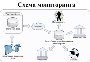
The Subsystem "Geoportal"
This subsystem is created as universal primary channel of interaction with customers and suppliers of GEODATA. From the point of view of users of the GIS portal is a single window access primarily to the metadata. It provides the search of necessary spatial information according to its description, as well as the direct production of GEODATA and digital maps.
The organisation of the GIS portal is a technology and software odnochipovogo Web-access to search, transfer and use of GEODATA and services at any point of the global Internet, and posting information on available someone data.
The main functions of the subsystem "Geoportal":
- Visualization of GIS data;
- View and edit metadata in the format of a GOST R 52573-2006 "Geographic information. Metadata" through a Web-interface.
- Access to a catalog of spatial data;
- Attribute search resources;
- The provision etc. of services (analytical processing of spatial data, monitoring, etc.)
The subsystem interface "Geoportal" is represented by a Web portal, therefore, for the GIS part, the main method of user access to information is access to the Web portal using any common browser. The core of the system provides the ability to:
- management static contents (shifts, scaling, etc.);
- storage of GEODATA (while the nomenclature sheets of digital maps, hereinafter referred to as objects) in the DBMS;
- full-text search;
- provide distributed access to services and data.
The composition subsystem includes a module "Server metadata", which publishes metadata in accordance with ГОСТ Р 52573-2006 "Geographic information. The metadata". Using this service, any holder of a spatial data can put information about their cartographic products.


