As reported by Vestnik GLONASS, the presence of the planet 8.6 billion mobile devices means that very often to get a clear signal – not easy.
However, the researchers claim that the new drone could help to rectify the situation.
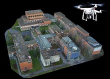
He will be able to create a detailed 3D map of the city that will allow researchers to simulate how radio waves pass through the city. The new method gives the opportunity to use photography and software to transform two-dimensional objects in the 3D model to construct a radio.
"Measurements and simulations that we produce in urban environments indicate that high-precision 3D model can dramatically improve the design quality of networks of millimeter-band radio", - said Vasily Semkin, head of the research group from Aalto University and University of Technology, Tampere (Finland).
Semkin and his team use a fleet of drones, some of which are operated manually, others using the program, pre-planted in a remote computer. Each drone is armed with a camera, able to obtain high-quality images of objects from different points of view. Images are sent to researchers, who treated them with specially photogrammetric software, which can produce three-dimensional models of objects. In the future these models are applied to simulate the propagation of radio waves.
"Designing wireless networks – not only for what we use our drones - continues Basil. – The Pentagon is using our technology – for example, to map the lair of the enemy. Shield AI develops systems for the Pentagon, which not only can hunt the enemies but to fly into buildings to show a picture of military commanders".


