28 декабря в Штаб-квартире РГО в Санкт-Петербурге состоится открытие выставки «Шедевры отечественной картографии XVIII века».
Картографическая коллекция Русского географического общества начала формироваться с момента основания организации. В основе коллекции произведения, составленные действительными членами Общества в экспедициях и исследованиях, а также из подарков меценатов. На протяжении значительного периода в конце XX столетия картографические материалы Общества не были в полной мере доступны. Сегодня, благодаря проведенной фондовой работе, впервые за долгое время стало возможным представить часть из них широкой публике.
Материалы выставки «Шедевры отечественной картографии XVIII века. Из фондов Русского географического общества» посвящены одному из важнейших периодов в картографии России – ее становлению в работах Императорской Академии наук.
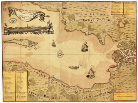 Schmidt, J. F. Geographical Map of the Gulf of Finland (1770). Copper engraving, laid paper. Kept spelling the XVIII century
Over a period of years map of the Geographic Department of the Academy of Sciences was considerable in scope and extremely important for the development of national geography work. The Department issued 324 of the printed map and has accumulated a vast Fund of 790 manuscript maps of Russia and its regions, served as the material for map-compiling works. Throughout the XVIII century it was the only science geographic and cartographic center in the country, combines research and practical functions. The scientific and public value of the work of the Department constitute one of the largest merit of the Academy of Sciences in the XVIII century.
Among the cards presented in the exhibition, of particular importance is the first complete Atlas of the Russian Empire of 1745, which is one of the most important milestones in the history of Russian cartography. Atlas, in addition to its scientific value, has a wonderful art decor. The elements used and the design of the exhibition space.
The basis of the exhibition, numerous maps of the Russian provinces and governorships, published throughout the eighteenth century. Central to the exhibition is devoted to the famous plan of Saint-Petersburg in 1753, is a recognized masterpiece of Russian engraving art, and Moscow's plan of 1765. Both pieces are decorated with drawings by the famous artist M. I. Makhaev (1717-1770). Of great value are the maps of the theatre of the Russo-Turkish war of 1735-1739 years, done on silk.
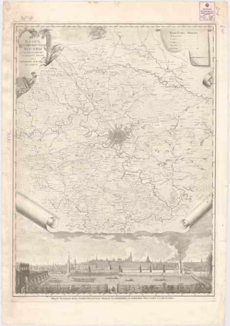
Plan tartousi of Moscow. the reading of the reclining seats on tridcati miles in the district, (1765). Copper engraving, laid paper. Kept spelling the XVIII century
The opening of the exhibition is an illustrated catalogue of the exhibition, which shows more details of the Geographic Department of the Academy of Sciences and the history of the creation of the works and their bibliographic descriptions with annotations.


