Terrestrial laser scanning of objects and areas
Professional ground-based laser scanning of objects and areas for various purposes enables you to quickly, cheaply and accurately enough to carry out the measurement and transfer of existing design solutions and relief in the electronic drawing project or a three-dimensional model.
Such digital product is used in further design and survey work and engineering and analytical activities, as well as in risk assessment and analysis of the feasibility of certain urban influences and reconstruction of industrial and infrastructure purposes.
Professionally and accurately
The Ural information-analytical center of JSC "Uralgeoinform" provides in Ekaterinburg qualified laser scanning of objects for various purposes using advanced scanning equipment and advanced software that allows you to transform the array data into a standard format for CAD.
Among the main applications of such services:
- Architectural design, construction and engineering surveys;
- Construction, reconstruction and operation of industrial enterprises;
- Road management;
- Mining, oil and gas industry;
- The energy security.
We perform laser scanning of territories is carried out entirely in an automated mode with an accuracy of 6 mm, the angle is 60 µrad. It allows to reduce time costs by 90%, reduce your costs and minimize the human factor.
The specialists of JSC "Uralgeoinform" perform work on the creation of digital three-dimensional models using modern laser scanning technologies for solving problems:
- visualization of spatial information in three-dimensional models of territories;
- visualization of spatial information in three-dimensional models of facilities with metric functions and the ability to work in various CAD programs;
- design, reconstruction of buildings and structures, etc.
The scope of the terrestrial laser scanning:
1. Architecture
Architectural measurements, geodetic support of the design and installation of facade structures; deformation control; 3D-modeling of buildings, streets and blocks; the preparation of detailed plans and 2D-drawings; monitoring of facades; creation and restoration of the Executive documentation and the creation of working drawings
 |
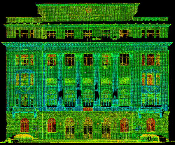 |
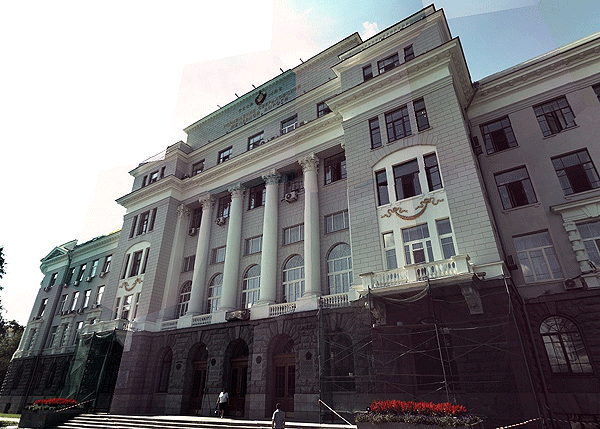
| Scanning the facade of the building | |
2. The construction and operation of buildings
3D-modeling; updating of the project during the construction process; optimal planning and control of movement, installation and removal of large parts of structures or equipment; installation works; monitoring of the state of the object during operation; the restoration of the lost drawings

Scanning site boiler
3. Management of roads
Shooting of the roadway, creating 3D terrain models; design, reconstruction and construction of infrastructure; diagnostics of rail track, construction access roads, control of limit values of deviations
4. Mining
3D modeling of open pits and underground workings; determination of volumes of mine workings and mine support drilling and blasting operations, construction and design of objects of arrangement of fields
5. The oil and gas industry
3D modeling, product pipelines, open pits and underground workings; high-precision digital models of complex technological objects and sites; inventory and monitoring; geometric control of reservoirs; mine support drilling and blasting operations; designing of objects of arrangement of fields
 |
 |
| Scanning the facade of the building | |
6. Energy
Shooting objects (cables, support structures), the creation of 3D models and installation works; monitoring of the state of the object, control of deformations, drawing up plans and drawings

Scanning site electrical substation
- Multiple use of data
The information obtained can be used to solve various tasks, using the original data of laser scanning, further processing and creation of three-dimensional models without re-shooting
- Optimization of time and cost
The time of the field research is reduced to 90%. Fast acquisition and update of information with high measuring accuracy (6 mm angle 60 microradian) and completeness of data received.
- The automation of measurements and data processing, surveying hard-to-reach and complex objects
- Minimization of "human factor" without stopping production
- Data compatibility with AutoCAD, Microstation, 3DMax
The results of the created model are transferred to CAD programs using standard formats dxf, dwg, txt and its own format, coe (Cloudworx Object Exchange)


