The creation of navigational map
The creation of navigational maps is a continually evolving process of creating a modern database of cartographic information settlements in accordance with the requirements of the new navigation systems.
To order a map of the information-analytical center "Uralgeoinform" in Ekaterinburg.
 |
") |
| Agreements were reached to convert the map of Khanty-Mansiysk to work with the program City Guide. The map of Khanty-Mansiysk entered into the European database navigation maps TeleAtlas. | Updated POI (points of interest) Khanty-Mansiysk |
 |
 |
| By order of the Ministry of defense created the navigation maps for GLONASS: scale 1: 10 000 to the city of Kumertau (Republic of Bashkortostan), scale 1: 10 000 of the city of Beloretsk (Republic of Bashkortostan), scale 1: 50 000 to the town of Nyagan (Khanty-Mansi Autonomous Okrug– Yugra). | |
Modern cartography
We develop digital navigation maps for the territory of the Ural Federal district under the modern equipment of navigation systems GPS and GLONASS, given the continuous expansion of the capabilities of the latest devices and spatial orientation.
Our work is carried out in such areas as mapping new areas and updating the geometry of roads and points of interest (POI) to the existing models considering the new navigation programs.
In their map development work, we use only high quality input data, including laser scanning and field survey of objects and territories.
The creation of the navigation map allows you to:
- To calculate the optimal route of the vehicle;
- To exclude traffic on minor roads;
- To quality address information.
Thanks to digital cartography considerably simplify the tasks of departments of logistics for flight planning, which contributes to higher efficiency of the motor transportation enterprises and cost optimization for transportation of various cargoes.
Products of JSC "Uralgeoinform" is of high quality, thanks to:
- The professionalism of the whole team;
- The use of modern scientific achievements and innovative technologies in the field of Geoinformatics;
- Rich experience of work.
To order our services you can go online on our website or in the office of the regional centre in Ekaterinburg.
Dispatch systems allow you to monitor traffic in real time on the monitor screen. The introduction of monitoring systems significantly improve economic indicators of transport efficiency and safety of personnel.
The system of monitoring of mobile objects allows you to:
- Automatically detect and transfer to computer or mobile phone the navigation parameters of the vehicle (location, movement, speed, etc.)
- Remotely pass commands to the driver of the vehicle
- To calculate the optimum route, make adjustments in real time based on actual data (for example, to arrange transport on less congested roads)
- To perform a statistical assessment to optimize logistics and work dispatch service
- To respond quickly in the event of unforeseen situations
Part of the dispatch system includes:
-
Software transmitting, receiving, routing, processing and storage of data, and also implements the user interface, protection against unauthorized access, etc.
-
The technical means to receive signals of satellite navigation systems to transmit their location to control computers, as well as having a number of additional functions such as the ability to remotely lock certain devices of the vehicle, a panic button, various sensors, etc. All this information is fed to control stations with a minimum interval of time.
-
Digital navigation maps, which are the most important criterion for visualization of the displayed information. The content of the card affects the time decision.
Special device "car navigation" is preloaded with a navigation map is designed for finding the optimal route taking into account speed characteristics of roads and even traffic jams.
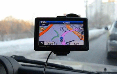
Car navigation allows you to:
- To move freely around an unfamiliar city or location
- To determine the optimal route
- To provide additional protection due to the presence of anti-theft system
- To use an extensive database of digital maps (it contains over 70 varieties of "points of interest" such as gas stations, hotels, hospitals, restaurants)
- To use a voice command the Navigator to the driver
- Monitoring of mobile objects
Part of the automotive navigation system includes:
- portable or built-in Navigator, car navigation map system
- digital navigation maps.


