Creating and updating digital topographic maps and plans of scale 1:500 - 1:1 000 000
List of main works performed by "Uralgeoinform" in 2005 to 2012.
- Created and updated (by the materials of space survey 2002 – 2006.) digital topographic maps of scale 1: 200 000 for the entire territory of the Ural Federal district in the following formats: Panorama, MapInfo, ArcGis (YNAO, KHMAO);
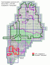
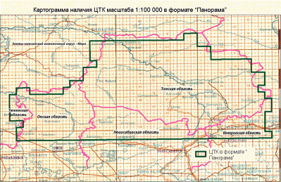
- Created digital topographic maps of scale 1:100 000 in the amount of 1935 item leaves;
- 1636 nomenclature sheets - format Panorama into the territory of the 20 subjects of the Russian Federation: Yamal-Nenetsk Autonomous district, the Tomsk, Omsk and Kurgan regions. Separate plots on the territory of Sverdlovsk, Chelyabinsk, Tyumen, Kirov, Ulyanovsk, Samara, Saratov, Volgograd, Orenburg, Novosibirsk and Kemerovo regions, Republic of Bashkortostan, the Perm and the Khabarovsk territory;
- 264 item list in the format of ArcGis on the territory of the Priuralsky, Purovsky and Tazovsky districts of Yamal-Nenets Autonomous district.
-
Created and updated (by the materials of space survey 2002 – 2006.) digital topographic maps of scale 1: 200 000 for the entire territory of the Ural Federal district in the following formats: Panorama, MapInfo, ArcGis (YNAO, KHMAO);
Created digital cartographic framework of the 1: 100,000 scale in the Panorama format and the MapInfo for the schemes of territorial planning on the territory of KHMAO-YUGRA, YANAO, Tyumen, Sverdlovsk, Chelyabinsk, Kurgan region, Republic of Bashkortostan, Perm Krai; -
Created digital topographic maps (topographic maps), scale 1: 25 000 on the territory of constituent entities of the Russian Federation: Sverdlovsk and Chelyabinsk region, Samara oblast, Perm Krai, Udmurtia, Orenburg oblast, Khanty-Mansi Autonomous Okrug – YUGRA ( the territory of the Central part of the County's updated images from the satellite Alos 2007 - 2008), the South of the Tyumen region – in the format of Panorama, MapInfo;
Created digital topographic maps:-
on the territory of the municipality "Yekaterinburg" in scale 1: 10 000, 1: 25 000 in format Ingeo, MapInfo in the amount of 1760 sq km from satellite imagery (QuickBird SPACECRAFT) updated digital topographic map, scale 1: 10 000 (address of plan);
-
on the territory of City district Sredneuralsk scale of 1: 10,000 MapInfo updated in satellite imagery 2005.;
-
on the territory of Novouralsk urban district scale 1: 25 000 in format Ingeo;
-
- Created digital maps for agricultural purposes scale 1: 10 000 for the territory of suburban areas and the Irbit Sverdlovsk region (on materials of aerial photography), Bogdanovicheskaya district of Sverdlovsk region (on materials of space shooting) – with a total area of 6615 km2 in MapInfo format;
- On the territory of the Republic of Bashkortostan created a digital topographic map of scale 1: 25 000 (14 municipal districts), orthophotos 1:10 000 (1st municipal district), topographic plans 1:5 000 (with 25 regional centers and large settlements);
- Created digital topographic maps of scale 1:10 000 for the territory of Ufa in Ingeo format and Mapinfo, year of creation 2010 as materials for updating the used space images in the World View 1,2.;
- Created digital topographic maps of scale 1:10 000 for the territory of the Ufa district in Ingeo format and Mapinfo, year of creation 2011 as materials for the upgrade were used orthophotos;
- Created digital topographic maps of scale 1:50 000 and 1:25 000 on the territory of the Turin urban region in the format of a Panorama and Ingeo.
Under orders of the enterprises and the commercial organizations completed:
- By order of LLC "LUKOIL – Western Siberia", JSC "Surgutneftegas", of the construction Department of KHMAO - Yugra created a digital topographic map of scale: 1: 200 000, 1: 100 000, 1: 25 000 formats: MapInfo, ArcGis. Works on updating of digital topographic maps (topographic maps) and plans of hydrocarbons scale 1: 25 000, 1: 5 000 according to the materials of space survey 2006 – 2008. on the territory of KHMAO-Yugra, YANAO.
- By order of the Department of building and architecture of administration of YANAO created topographical basis of scale 1: 1 000 in MapInfo format for the information system of the state urban cadastre of p. Yar-sale.
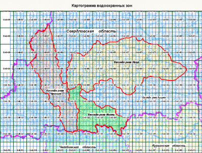
- By order of the Ministry of natural resources of Sverdlovsk region determined the boundaries of water protection zones and coastal protective strips of water objects of the river basins Iset, Nice, Chusovaya within the Sverdlovsk region and created thematic maps of water protection zones and coastal shelterbelts on cartographical basis of scale 1: 25 000 in format MapInfo.
 |
Cartogram of digital thematic maps of scale 1:25,000 the boundaries of water protection zones of water objects on the territory of the river basins Iset, Nice, Chusovaya |
- By order of the Federal state unitary enterprise "radio frequency centre of the Urals Federal district":
- original digital topographic maps of scale 1: 25 000 (MapInfo) on the territory of the city of the Ural Federal district: Eekaterinburg (year status location YSL 1999), Kamensk-Ural (2007 YSL), bakery in Pyshma (2007 YSL), Serov (YSL, 1992), Nizhny Tagil (YSL 1987), Tyumen (YSL, 1991), Kurgan (YSL, 1994), Magnitogorsk (YSL 1998), Petukhovo (YSL 2008.) Khanty-Mansiysk (2007 YSL), Nizhnevartovsk (2007 YSL), Surgut (2006 YSL), Nyagan (2007 YSL), Noyabrsk (2007 YSL), Novy Urengoy (YSL 2001), Kogalym (YSL 2006), Raduzniy (YSL 2006), Sovietsky (YSL 2006), Surgut (YSL 2006), Tobolsk (YSL 2006), Uray (YSL 2006), Yugorsk (YSL, 1992), Zlatoust (YSL 1995.) Miass (YSL 1995.) Chelyabinsk (YSL, 1995).
- MapInfo created a digital topographic map of scale 1: 10 000 (address terms) of the towns: Serov, Nizhny Tagil (Sverdlovsk region), Chelyabinsk, Magnitogorsk, Zlatoust, Miass (Chelyabinsk oblast), Kurgan, Shadrinsk (Kurgan oblast);
- created a digital topographic map, scale 1: 1 000 000 on the territory of the Urals Federal district (in formats MapInfo and Panorama).
- By order of JSC "Airport Koltsovo" have created a digital thematic map of Yekaterinburg масштаба1:25 000 in format Ingeo, in the amount of 1760 sq km and a digital topographic map (topographic map) environs of Ekaterinburg, scale 1:25 000 in the amount of 1254 square kilometres in the format of Panorama, to provide a reliable cartographic and thematic information of the technical services of the airport "Koltsovo".
- In the framework of the GIS project "Socio-hygienic monitoring of the Sverdlovsk region" (GIS SGM) an electronic plan is the address plan 13 cities of Sverdlovsk region: Yekaterinburg, Nizhny Tagil, Kamensk-Uralsky, Serov, Pervoural'sk, Pervouralsk, Verkhnyaya Pyshma, Krasnoturinsk, Karpinsk, krasnoural'sk, Kirovgrad, Polevskoy, Asbestos, scale 1:10 000, 1:25 000 in format Ingeo.
- For master plan, Berezovsky created electronic topographic base address plan scale 1:5000 in Ingeo format.
Creating and updating digital maps is performed with application of the developed technologies on the organization and unification of geospatial information using end-to-end mapping of the classifier for the scale 1: 500 – 1: 1 000 000 and uniform rules of digital description.
Digital topographic maps can effectively solve a number of important tasks for the development of a specific area in economic, infrastructure and social sectors.
Preparation of digital thematic maps with the exact application of the required mapping information branch assignment gives you the opportunity to analyze landscape, geological, industrial and social infrastructure for the planning of further development.
Information-analytical center "Uralgeoinform", located in Eekaterinburg, is part of the state company "Roskartografiya", allowing efficient creation of digital topographic maps, taking into account all norms and Standards in map production using advanced technologies, satellite systems and aerial photography.
Scope
These services provide the opportunity to update the existing GIS database and to make a clear analysis:
- Sanitary conditions of the territory;
- Condition of objects of cultural heritage;
- The effectiveness of urban planning solutions;
- Safety industrial construction, including elevation and direction of the wind;
- Strategic transport infrastructure planning.
In addition, digital topographic maps and plans enable you to assess the damage due to emergencies and other geoprocesses in the space-time context.
These services are carried out on advanced mapping equipment using modern highly qualified certified specialists. To order digital topographic plan you can scale from 1:500 to 1:1 000 000.


