Organization of spatial data
The organization of spatial data (cartographic and thematic classifiers, rules of digital description, convert)
Specialists of the Department on formation of structure of spatial data ", Uralgeoinform" perform work on the standardization of geospatial information in a single structure and the formation of a Bank of digital cartographic information for the territory of the Ural Federal district.
Work performed:
- Through the classifier cartographic information of scales 1: 1000 000 — 1: 500

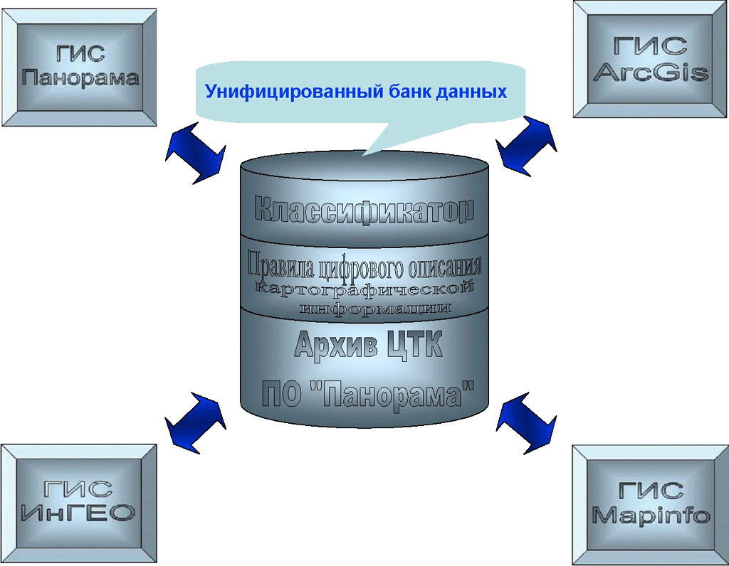
The classifier meets the standards of Roskartografiya and Standards. Can be applied to any database management System
The classifier is implemented in the formats "Panorama" (for scale 1: 200 000, 1: 100 000, 1: 50 000, 1: 25 000, 1: 10 000), "Ingeo" (1: 200 000, 1: 25 000, 1: 10 000, 1: 5 000, 1: 2 000, 1: 500), MapInfo (classifier 1: 500 - 1: 1 000 000). The classifier can be modified according to customer requirements.
- Rules of digital description of cartographic information


Designed in the form of detailed instructions. Facilitate the process of establishment and harmonization of spatial data
For Panorama: zoom 1: 10 000, 1: 25 000, 1: 50 000, 1:100 000, 1:200 000
For GIS Ingeo: 1: 500, 1:2 000, 1:5 000, 1:10 000, 1:25 000, 1:100 000, 1:200 000
For MapInfo 1: 500 - 1: 1 000 000
-
Table design for digital topographic maps and plans
scale 1: 500 - 1: 000 000 for FOR Mapinfo - Thematic classifications and the rules of the digital description of the subject information (for the master plan of socio-hygienic monitoring, environment, emergencies, water protection zones, the project planning area (city of Eekaterinburg) and landscaping (city of Eekaterinburg), traffic signs and road markings)


- The technology of automated design of master plan of development of territories
")
Fragment of a document (a book on the technology of automation schemes GP)
Classifiers, rules of digital description and sample registration allows you to:
- To simplify the process of creating cartographic products
- To increase efficiency with ready-made cartographic products
- To facilitate interagency cooperation
- The data structure is prepared for any database management system
- Technology conversion from Panorama in Mapinfo for scale 1: 10 000, 1: 25 000, 1:1:100 000, 1:200 000.
The documents consists of:
- Converter,
- Configuration files for conversion
- File design of cartographic objects
- A description of the technology conversion.Documents for converting from Panorama to Ingeo, the Ingeo in Panorama and from Ingeo вMapInfo.
The technology of the conversion and samples the design of digital topographic maps and plans allows you to:
quickly translate data from one format to another without loss of information in automatic mode to execute a digital map or a plan
Ongoing projects:
Normative documents for creation of Schemes of territorial planning of the Russian Federation.
The main goal of the project is the optimization of work in the creation of schemes of territorial planning at all levels of governance: the Russian Federation, constituent entities of the Russian Federation and municipal entities and harmonization of data for integration of departmental information resources.
The results of the project
The composition of the normative documents:
1. The classified structure objects of the scheme of territorial planning of the Russian Federation;
2. Rules of digital description of the subject information,
3. Unified graphic design of the scheme of territorial planning of the Russian Federation.
The list of objects to be displayed on maps and in territorial planning schemes, developed in accordance with existing regulations:
- Town planning code of the Russian Federation, 2004;
- The water code of the Russian Federation, 2006,
- The air code of the Russian Federation, 1997;
- Land code, 2001;
- Forest code of the Russian Federation, 2006,
- The inland water transport code of the Russian Federation, 2006,
- The customs code of the Russian Federation, 2003;
- The Federal Law "On objects of cultural heritage", 2008 (No. 160-FZ);
- The Federal Law "On automobile roads and road activity", 2007 (№ 257-FZ);
- Order of the Minister of regional development of the Russian Federation of 31 January 2007, No. 4.
In order to minimise potential difficulties when completing attributes, provides for an appeal of the existence of an all-Russian industry classification:
- All-Russian classification of products on types of economic activities;
- Russian classification of objects of administrative-territorial division (OKATO);
- All-Russian classifier of municipal unit territories (OKTMO);
- All-Russian classifier of forms of ownership;
- Russian classification of economic regions;
- Other normative documents.
The list of objects allows you to create an approved part of the scheme of territorial planning of the Russian Federation. For standardizing the data on the cards (schemes) on a substantiation of projects of schemes of territorial planning requires an expansion of the objects with their inherent attributes. Developed regulatory documents undergoing approval in the Ministry of regional development of the Russian Federation. It is expected the adoption of documents at the Federal level.
Continues development of normative documents for the preparation of schemes of territorial planning of subjects of the Russian Federation and municipal entities.


