GIS of historical and cultural heritage
Territorial GIS of historical and cultural heritage (HCH) with the current database makes it possible to provide effective control of architectural, archaeological and natural objects ikn in a dynamic urban development.
Often monuments and other cultural heritage objects (CHO) are subject to the unlawful demolition or reconstruction in the absence of clear tools to track and prevent such unauthorized actions.
The Ural information-analytical center of JSC "Uralgeoinform" is located in Eekaterinburg and is part of the state company "Roskartografiya", which allows to perform the compilation and updating of various large industry, General and territorial geographic information systems. GIS ikn allow municipal authorities to better perform the monitoring function and to control the saving of resources.
Among the main functions:
- Visualization window on digital maps;
- Forecasting the development and maintenance of the register of objects ikn;
- The collection of statistical data;
- Automation of document flow and interdepartmental cooperation.
Territorial GIS of historical and cultural heritage
Currently, due to the high dynamics of development of our society and the rapidly changing appearance of cities, there is a need of effective use and preservation of historical, cultural and archaeological heritage of the area. For complex solution of such problems, "Uralgeoinform" performs the development of the regional geographic information system "Historical-cultural heritage" (GIS "HCH").
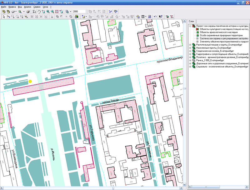
- The display of objects of cultural heritage (OCH) on digital maps and plans;
- Forecasting (OCH);
- Registers (OCH) of Federal and regional value;
- The automated formation of documents according to the developed template.
- Ensuring the collection of necessary statistical information on the documents, monitoring deadlines;
- Organization of interdepartmental interaction.
Components of GIS: cartographic database,registry database and specialized software ( automation of workflow).
1. Maps database
includes digital vector maps and plans of historical cities with the visualization of thematic information:
- The objects of historical-cultural heritage;
- Projects of security zones;
- Plans for dissemination of the monuments of archeology;
- Schematic of the phased development of historic cities;
- The historical-architectural basic plans.

Experience with mapping information allows to edit, create, and delete objects
For monitoring and forecasting development of historic towns and individual objects three-dimensional model.
2. The information part of the system
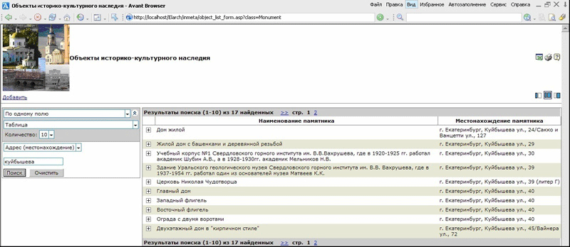
allows you to register data on objects of cultural heritage.

The information part of the system
The information and mapping parts of the system are connected, whereby the user can obtain complete information about an object represented on a digital map, or determine the location of an object on the ground.
3. Specialized software (automation of workflow)
Allows you to store an electronic archive of all documents throughout their life cycle. Features for users: automatic generation of outgoing documents, monitoring the expiry dates and generate statistical data.
The system is implemented using the following software: GIS "Ingeo", a development environment "Inmate" (CSS "Integro", Ufa) and the database management system MS SQL Server. The system is installed on the server, access can be obtained via a standard Web browser from any client network.
For a visual representation of territories and objects of historical and cultural heritage in the composition of the Bank included three-dimensional (3D) models of monuments of history, culture and architecture.
Digital model of the territory of the Kremlin of Verkhoturie
Digital model of the Nevyansk tower
The implementation of the system allows solving the following tasks:
- Improvement of control of preservation and use of cultural heritage and protection zones;
- Visualization of cultural heritage on cartographic materials;
- Maintenance of registry database objects, automate the workflow;
- The creation of a single information space for the interaction with government agencies and outside organizations/
Advantages of the system:
- Improving the convenience and efficiency of employees;
- Tracking deadlines of documents;
- Minimizing the risk of loss or change of information;
- Decrease of time costs on the formation documents;
- Improving the quality of management;
- Budgetary savings.
Geographic information system "Historical and cultural heritage", developed taking into account the specifics of a particular region, can be used in the territorial bodies of protection of objects of cultural heritage of the Russian Federation subjects, bodies of local self-government and other business entities.
Currently, the system is designed and successfully operated at the following institutions:
- Department of state protection of objects of cultural heritage, Ministry of culture of the Sverdlovsk region;
- Scientific-production center on protection and use of monuments of history and culture of the Sverdlovsk region;
- Service of the state protection of objects of cultural heritage of the Republic of Buryatia.
Integration with the Geoportal of the Ural region
(разработчик АО «Уралгеоинформ» по заказу Роскартографии).
(developed by JSC "Uralgeoinform" by the order of Roskartografiya).
The geoportal is created in the framework of the state program on development of the main elements of the Russian spatial data infrastructure (ISEPA). The main idea of the Geoportal is the integration on a uniform cartographical basis of departmental information systems of the Ural Federal district to ensure effective monitoring of geo-data and other spatial information. The project planned the creation of services for organizations in the areas of education, tourism, construction, insurance, etc., as well as for individuals and commercial organisations.

Publication of the GIS data, "Historical-cultural heritage of Sverdlovsk region" on the Geoportal of the Ural region
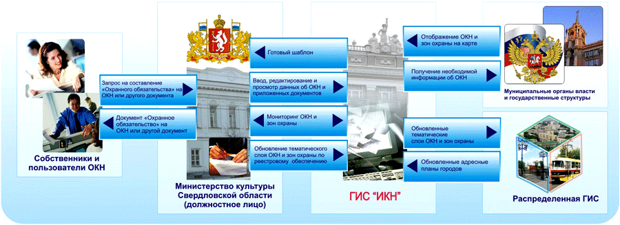
The organization due to "a Distributed geographic information system"(DGIS) municipal education Ekaterinburg
A distributed geographic information system provides access to updated mapping and thematic data through the organization of interagency information exchange.

Place GIS "Historical-cultural heritage of Sverdlovsk region" in the support system conservation of cultural heritage


