Services
Subsystem "Storage feature"
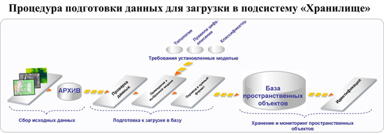
Conceptual base feature is created as a repository of information about the real topography. Storage is the main component of the Bank of geospatial data. Download "Storage" are subject to spatial features extracted from the digital maps of different scales.
The basic functions of the subsystem:
- Storing information on spatial objects (attribute, metric, object, metadata);
- Download of feature sets in a standardized format;
- Unloading sets of digital data, including in the form of nomenclature sheets of digital topographic maps, and the formation of geospatial data for publication on the geoportal;
- Edit, and monitor information about spatial objects;
- Ensuring interoperability of digital cartographic data;
The basic principles of building information models of the spatial objects in the object database:
- De-duplication coordinate and attribute descriptions feature;
- A coherent view of all information on a specific feature;
- The ability to store several metric descriptions for the same object;
- Different sources of a coordinate description;
- The possibility of describing hierarchical relationships between objects, etc.
In parallel with the creation of the "Store" is developing technologies for the preparation of objects to load in the object database.