Components of the project
Components of the project
- Map unit
- The analysis unit
- Workstation
- Data Bank
For the purposes of the road management uses digital maps and plans of various scales and content: plans of scale 1:500 for problems of designing engineering structures to review maps of scale 1:500000 for a comprehensive assessment of the situation in the region and strategic planning development of road network. At this point in the Toolkit GIS "Roads of Yugra" for the Road Department for KHMAO-Yugra includes:
- Digital topographic map scale 1:500 000, 1:200 000 on the territory of the "pilot" of the region,
- Digital topographic map scale 1:25 000 (3-kilometer strip along roads and winter road in the territory of the "pilot" region),
- Digital topographic plan scale 1:2 000 for the road "pilot" of the region.
Digital topographic map scale 1:500000
Overview map for the tasks of strategic planning and engineering studies.

Overview map of scale 1:500 000
Digital topographic map scale 1:200 000
Overview map for the preliminary calculations in the design of large structures and spatial planning.

Overview map of scale 1:200 000
Digital topographic map scale 1:25 000
Designed for the following objectives:
- A detailed assessment of the area;
- Measurements and calculations of engineering structures;
- Construction, topographic surveys, determination of coordinates of objects.
Digital topographic plan scale 1:2 000
Designed for:
- generate the initial data for the road design and working drawings;
- the design of transport interchanges;
- inventory of roads.
Work with map unit
The system is built such that any data object can have a spatial representation. For this representation meets map unit systems, managing the digital maps as a specialized data store. This gives you the ability to associate diverse information through its cartographic representation.
The combination of data elements by means of map unit:
 |
 |
| space the site | space the imposed way (the object representation of the "traffic data Bank") and bridge construction (the representation of the object of AIS data "ISSO") |
") |
 |
| depicts the status of precedent road traffic accident (RTA) | System in the workplace transferred to a semantic data view: the data on road accidents presented in complex in form due to spatial Association with other objects |
An analytical framework is an extensible software system, responsible for all tasks of data processing. In a pilot version of the system analysis unit performs the following tasks:
- formation of the samples by the given search pattern;
- formation of summary reports.
Sample
GIS "Road-Yugra" has the functions of information search. Feature selection is carried out after entering the search criteria. In the framework of a pilot project that provides templates, search for the following object types:
- road;
- bridges and overpasses;
- water-conducting pipe;
- precedents of road accidents.

A request for a sample of roads
Reports
Functions are implemented the formation in automatic mode some news reports (in particular, passport and diagnostic indicators control objects).

The formation of a consolidated report on the geometrical parameters of roads in all district with automatic export to Microsoft Excel
User access to system functions is carried out by a special application workstation. Its interface was carefully designed taking into account features of application of geoinformation technologies for the decision of problems of management of the road:
- the necessity of convenient and rapid formation of maps of different scale and fullness to an arbitrary portion of the territory;
- large volumes of heterogeneous information: passport, diagnostic, monitoring data, diagrams and plans of engineering structures, videography, pivot tables, graphs and charts, etc.;
- information should be organized taking into account the chronology and sources of income;
- a large number of data processing tools (statistical and visual analysis of accounting data, automatically generate documentation, search and retrieval of information, etc) should not "overload" the system, making it difficult to use;
- access to information should be organized taking into account the powers and functions of the current user;
- other features.
The result of this research was the concept UI based on modern recommendations of the Microsoft Corporation used in applications such as Microsoft Office.
 |
 |
|
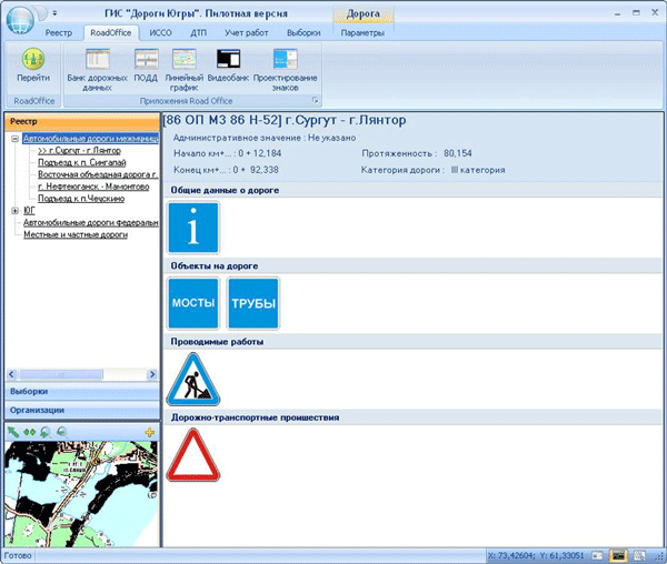
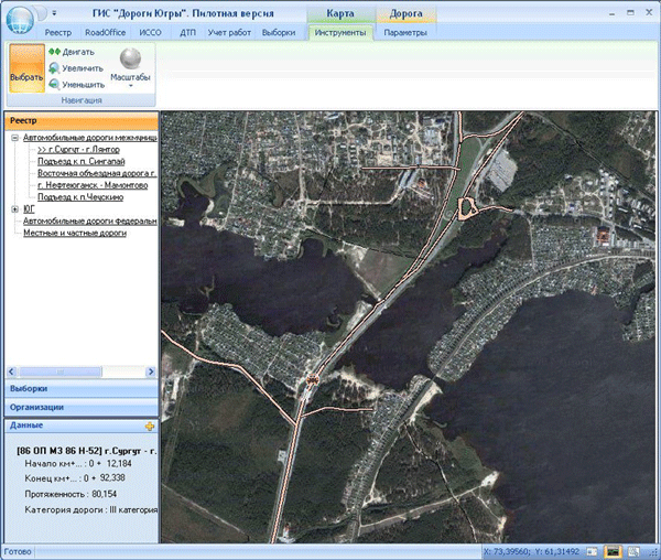
The view of the workstation GIS "Roads of Yugra" (in two modes of data representation) |
|
In terms of information and functionalities of the system, the user has the ability to quickly switch between the two modes of data presentation:
A semantic view of data
Information about selected objects (e.g., road or engineering structure) is represented as numeric or text parameters and characteristics: length, width, materials, administrative affiliation, etc.
Map view data
The main part of the system is the digital map that the user can work in interactive mode and to request the display of selected or processed data (e.g. a road network or summary reports, disaggregated by territorial units).
In addition to the view data, the system can be set to one of the three "functional modes":
- Work with the accounting records;
- Reporting and analysis data;
- Input.
This solution enables us to "unload" the interface functionality, which was not needed when performing a particular type of work.
Demonstration of GIS "Road KHMAO-YUGRA"


