The current version of the GIS "Roads of Yugra"
The current version of the GIS "Roads of Yugra"
The main components of a pilot version of the GIS "Roads of Yugra" functional displays model:
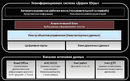
Central to the system is the registry management objects (roads), which is formed on the basis of the List of public roads approved by the County government. The rest is stored and processed by the system information is contained in the so-called "specialized storage" (in the figure are grayed out). Two specialized storage ("Digital maps" and "road data Bank") are part of the system and the remaining storage is treated as external data sources. This solution allows to organize a consistent, coherent data Bank on roads, while maintaining the flexibility and extensibility of the system.
The ability to connect external data sources is one of the main benefits of GIS "Roads of Yugra" in comparison with the competing analogues. The process of implementation does not imply a one-time waiver already software: the system can combine the programs used in a single solution.
So, today, the system handles data and software systems: Road Office; and AIS, ISSO (light of the information about artificial structures on the roads).
We developed 2 specialist module: the module "works" and the module "road traffic accidents"
Read more about the modules
- Accounting module of works carried out by contractors within the framework of the processes of operation of the road network ("Accounting works"). In a pilot project GIS "Road-Yugra" functions are implemented to account for the volume and value of operations carried out on objects, on standard forms KS-2 and KS-3. Enter information about the work done on the object is in the "Input accounting data".

Module "Accounting work"
- Accounting module of accidents ("road traffic accidents"). One of the important factors in the assessment of the condition of the roads is the monitoring of the precedents of road accidents. GIS "Road-Yugra" allows to take into account the traffic accident for further analysis using spatial information. The system allows to register in the database, the precedent of the accident in terms of the standard forms provided in the Department of Road inspection of traffic police. In terms of data accumulation it is possible to form a summary report to produce a sample and display cases of accident on the map.

The module "road traffic accidents"
The current version of the GIS "Roads of Yugra" is a distributed application with a strictly isolated software interfaces. Software providing the functions of the system based on the mechanism of the Microsoft Web-Services. Central information units of the system operate with the data under control of DBMS Microsoft SQL Server 2005. The arm application is a Windows Forms application that requires Microsoft Windows version XP (2003), the availability of the Microsoft platform .NET 3.5 and Microsoft


